Weather Alert in California
Red Flag Warning issued August 20 at 3:34PM PDT until August 23 at 9:00PM PDT by NWS Los Angeles/Oxnard CA
AREAS AFFECTED: Santa Clarita Valley; Santa Susana Mountains; Southern Ventura County Mountains; Northern Ventura County Mountains; Interstate 5 Corridor; Western San Gabriel Mountains and Highway 14 Corridor; Eastern San Gabriel Mountains; Western Antelope Valley Foothills; Eastern Antelope Valley Foothills
DESCRIPTION: ...RED FLAG WARNING IN EFFECT UNTIL 9 PM PDT SATURDAY FOR AN UNSEASONABLY HOT AND UNSTABLE AIR MASS CAPABLE OF PRODUCING EXTREME FIRE BEHAVIOR FROM VERTICAL PLUME GROWTH... LOW RELATIVE HUMIDITY...AND LOCALLY BREEZY WINDS FOR PORTIONS OF THE MOUNTAINS AND FOOTHILLS OF LOS ANGELES AND VENTURA COUNTIES... ...RED FLAG WARNING IN EFFECT FROM 9 AM PDT THURSDAY TO 9 PM PDT SATURDAY FOR AN UNSEASONABLY HOT AND UNSTABLE AIR MASS CAPABLE OF PRODUCING EXTREME FIRE BEHAVIOR FROM VERTICAL PLUME GROWTH...LOW RELATIVE HUMIDITY...AND LOCALLY BREEZY WINDS FOR PORTIONS OF THE MOUNTAINS AND FOOTHILLS OF SANTA BARBARA AND SAN LUIS OBISPO COUNTIES... .A significant heatwave is on the way for late this week into this weekend, bringing dangerous fire-weather conditions. * TEMPERATURES...Unseasonably hot high temperatures, generally 95- 110 degrees and highest Thursday through Saturday, producing unseasonably unstable conditions. * RELATIVE HUMIDITY...Minimum relative humidity 8-20 percent, lowest Wednesday and Thursday. * THUNDERSTORMS...Isolated thunderstorms will be possible Friday through the weekend, and any accompanying lightning strikes will be capable of starting new fires on the peripheries of rain cores. * WINDS...Southwest at 10-20 mph gusting to 20-25 mph over the western Antelope Valley Foothills and vicinity and in other wind- favored areas such as through passes and canyons. Lighter winds elsewhere. Passing outflow boundaries could bring sudden wind- shifts and increased fire-spread rates, even from distant thunderstorms. * IMPACTS...If fire ignition occurs, conditions are favorable for extreme fire behavior and rapid fire growth, which could threaten life and property. Be aware of sudden re-direction of fires in response to passing outflow boundaries. * ADDITIONAL DETAILS...Fire-weather headlines may eventually need to be extended into Sunday.
INSTRUCTION: A Red Flag Warning means that fire-weather conditions are expected to be favorable for the development of extreme fire behavior. Use extreme caution with anything that can spark a wildfire. Residents near wildland interfaces should be prepared to evacuate if a wildfire breaks out. See readyforwildfire.org and wildfirerisk.org for information.
Want more detail? Get the Complete 7 Day and Night Detailed Forecast!
Current U.S. National Radar--Current
The Current National Weather Radar is shown below with a UTC Time (subtract 5 hours from UTC to get Eastern Time).

National Weather Forecast--Current
The Current National Weather Forecast and National Weather Map are shown below.

National Weather Forecast for Tomorrow
Tomorrow National Weather Forecast and Tomorrow National Weather Map are show below.

North America Water Vapor (Moisture)
This map shows recent moisture content over North America. Bright and colored areas show high moisture (ie, clouds); brown indicates very little moisture present; black indicates no moisture.

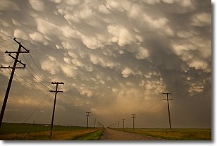
Weather Topic: What are Mammatus Clouds?
Home - Education - Cloud Types - Mammatus Clouds
 Next Topic: Nimbostratus Clouds
A mammatus cloud is a cloud with a unique feature which resembles
a web of pouches hanging along the base of the cloud.
In the United States, mammatus clouds tend to form in the warmer months, commonly
in the Midwest and eastern regions.
While they usually form at the bottom of a cumulonimbis cloud, they can also form
under altostratus, altocumulus, stratocumulus, and cirrus clouds. Mammatus clouds
warn that severe weather is close.
Next Topic: Nimbostratus Clouds
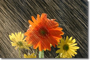
Weather Topic: What is Precipitation?
Home - Education - Precipitation - Precipitation
 Next Topic: Rain
Precipitation can refer to many different forms of water that
may fall from clouds. Precipitation occurs after a cloud has become saturated to
the point where its water particles are more dense than the air below the cloud.
In most cases, precipitation will reach the ground, but it is not uncommon for
precipitation to evaporate before it reaches the earth's surface.
When precipitation evaporates before it contacts the ground it is called Virga.
Graupel, hail, sleet, rain, drizzle, and snow are forms of precipitation, but fog
and mist are not considered precipitation because the water vapor which
constitutes them isn't dense enough to fall to the ground.
Next Topic: Rain
Current conditions powered by WeatherAPI.com


