Weather Alert in Virginia
Flash Flood Warning issued August 21 at 7:29PM EDT until August 21 at 10:30PM EDT by NWS Blacksburg VA
AREAS AFFECTED: Botetourt, VA; Franklin, VA; Roanoke, VA; City of Roanoke, VA; City of Salem, VA
DESCRIPTION: FFWRNK The National Weather Service in Blacksburg has issued a * Flash Flood Warning for... Southwestern Botetourt County in west central Virginia... Northwestern Franklin County in west central Virginia... Roanoke County in west central Virginia... The City of Roanoke in west central Virginia... The City of Salem in west central Virginia... * Until 1030 PM EDT. * At 729 PM EDT, gauge reports indicated thunderstorms producing heavy rain across the warned area. Between 2 and 3 inches of rain have fallen. The expected rainfall rate is 1.5 to 3 inches in 1 hour. Additional rainfall amounts of 0.5 to 1.5 inches are possible in the warned area. Flash flooding is ongoing or expected to begin shortly. HAZARD...Flash flooding caused by thunderstorms. SOURCE...Gauges reported. IMPACT...Flash flooding of small creeks and streams, urban areas, highways, streets and underpasses as well as other poor drainage and low-lying areas. * Some locations that will experience flash flooding include... Roanoke... Salem... Vinton... Boones Mill... Catawba... Cave Spring... Hollins... This includes the following streams and drainages... Big Bear Rock Branch, Back Creek, Carvin Creek and Buffalo Creek.
INSTRUCTION: Turn around, don't drown when encountering flooded roads. Most flood deaths occur in vehicles. Be aware of your surroundings and do not drive on flooded roads. Stay away or be swept away. River banks and culverts can become unstable and unsafe. When it is safe to do so, please send your reports of flooding, including mudslides or flooded roads, to the National Weather Service by calling toll free at 1...8 6 6...2 1 5...4 3 2 4. Reports and pictures can also be shared on the National Weather Service Blacksburg Facebook page and on X.
Want more detail? Get the Complete 7 Day and Night Detailed Forecast!
Current U.S. National Radar--Current
The Current National Weather Radar is shown below with a UTC Time (subtract 5 hours from UTC to get Eastern Time).

National Weather Forecast--Current
The Current National Weather Forecast and National Weather Map are shown below.

National Weather Forecast for Tomorrow
Tomorrow National Weather Forecast and Tomorrow National Weather Map are show below.

North America Water Vapor (Moisture)
This map shows recent moisture content over North America. Bright and colored areas show high moisture (ie, clouds); brown indicates very little moisture present; black indicates no moisture.

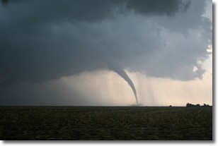
Weather Topic: What are Wall Clouds?
Home - Education - Cloud Types - Wall Clouds
 Next Topic: Altocumulus Clouds
A wall cloud forms underneath the base of a cumulonimbus cloud,
and can be a hotbed for deadly tornadoes.
Wall clouds are formed by air flowing into the cumulonimbus clouds, which can
result in the wall cloud descending from the base of the cumulonimbus cloud, or
rising fractus clouds which join to the base of the storm cloud as the wall cloud
takes shape.
Wall clouds can be very large, and in the Northern Hemisphere they generally
form at the southern edge of cumulonimbus clouds.
Next Topic: Altocumulus Clouds
Weather Topic: What are Altostratus Clouds?
Home - Education - Cloud Types - Altostratus Clouds
 Next Topic: Cirrocumulus Clouds
Altostratus clouds form at mid to high-level altitudes
(between 2 and 7 km) and are created by a warm, stable air mass which causes
water vapor
to condense as it rise through the atmosphere. Usually altostratus clouds are
featureless sheets characterized by a uniform color.
In some cases, wind punching through the cloud formation may give it a waved
appearance, called altostratus undulatus. Altostratus clouds
are commonly seen with other cloud formations accompanying them.
Next Topic: Cirrocumulus Clouds
Current conditions powered by WeatherAPI.com


