Weather Alert in Maine
Rip Current Statement issued August 21 at 2:56AM EDT until August 21 at 8:00PM EDT by NWS Gray ME
AREAS AFFECTED: Coastal York; Coastal Cumberland; Sagadahoc; Lincoln; Knox; Coastal Rockingham
DESCRIPTION: * WHAT...For the High Rip Current Risk, dangerous rip currents expected. For the High Surf Advisory, large breaking waves of 6 to 10 feet and a high risk of dangerous rip currents. * WHERE...In Maine, Coastal York, Coastal Cumberland, Sagadahoc, Lincoln and Knox Counties. In New Hampshire, Coastal Rockingham County. * WHEN...For the High Rip Current Risk, from 6 AM EDT this morning through this evening. For the High Surf Advisory, from 6 AM Friday to 8 PM EDT Saturday. * IMPACTS...Dangerous swimming and surfing conditions and localized beach erosion. Rip currents can sweep even the best swimmers away from shore into deeper water.
INSTRUCTION: Inexperienced swimmers should remain out of the water due to dangerous surf conditions. Swim near a lifeguard. If caught in a rip current, relax and float. Don't swim against the current. If able, swim in a direction following the shoreline. If unable to escape, face the shore and call or wave for help. Large waves can present a danger to people on rocks above the water. Stay away from rock outcrops along the shoreline exposed to ocean waves...as waves can easily sweep people into the cold ocean water.
Want more detail? Get the Complete 7 Day and Night Detailed Forecast!
Current U.S. National Radar--Current
The Current National Weather Radar is shown below with a UTC Time (subtract 5 hours from UTC to get Eastern Time).

National Weather Forecast--Current
The Current National Weather Forecast and National Weather Map are shown below.

National Weather Forecast for Tomorrow
Tomorrow National Weather Forecast and Tomorrow National Weather Map are show below.

North America Water Vapor (Moisture)
This map shows recent moisture content over North America. Bright and colored areas show high moisture (ie, clouds); brown indicates very little moisture present; black indicates no moisture.

Weather Topic: What is Condensation?
Home - Education - Precipitation - Condensation
 Next Topic: Contrails
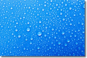
Condensation is the process which creates clouds, and therefore
it is a crucial process in the water cycle.
Condensation is the change of matter from a state of gas into a state of liquid,
and it happens because water molecules release heat into the atmosphere and
become organized into a more closely packed structure, what we might see as
water droplets.
Water is always present in the air around us as a vapor, but it's too small for
us to see. When water undergoes the process of condensation it becomes organized
into visible water droplets. You've probably seen condensation happen before on the
surface of a cold drink!
Next Topic: Contrails
Weather Topic: What are Cumulonimbus Clouds?
Home - Education - Cloud Types - Cumulonimbus Clouds
 Next Topic: Cumulus Clouds
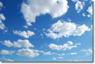
The final form taken by a growing cumulus cloud is the
cumulonimbus cloud, which is very tall and dense.
The tower of a cumulonimbus cloud can soar 23 km into the atmosphere, although
most commonly they stop growing at an altitude of 6 km.
Even small cumulonimbus clouds appear very large in comparison to other cloud types.
They can signal the approach of stormy weather, such as thunderstorms or blizzards.
Next Topic: Cumulus Clouds
Current conditions powered by WeatherAPI.com


