Weather Alert in Alaska
Winter Weather Advisory issued March 20 at 1:00PM AKDT until March 21 at 7:00PM AKDT by NWS Juneau AK
AREAS AFFECTED: Glacier Bay; Eastern Chichagof Island; City and Borough of Juneau
DESCRIPTION: ...ANOTHER PERIOD OF SNOW FOR THE CENTRAL AND NORTHERN PANHANDLE THIS WEEKEND... .Confidence is increasing on seeing a more significant round of snow this weekend as cold temperatures aloft remain in place and another round of moisture moves in. There remains some uncertainty for snow accumulations at the surface as Saturday afternoon temperatures at sea level are reaching into the mid 30s to around 40 due to increasing daylight and sun angle. However, temperatures aloft are still very favorable for accumulating snow amounts. If the heavier precipitation rates are significant enough to overcome the warmer surface temperatures, snow accumulations will be greater. But if the temperatures are able to overcome the precipitation rates, snowfall will be limited as it melts by the time it reaches the surface. This will need to be monitored for any changes in potential snow accumulation. The orientation of the low and where the showers move into the panhandle will also impact the snow amounts, with how northward and inland the heavier moisture will push and how organized the bands of snow are expected to be when moving through this weekend. Highest snow rates are expected Saturday morning before warmer temperatures in the afternoon begin to limit snow accumulation. * WHAT...Snow expected. Total snow accumulations of 3 to 5 inches. Winds gusting as high as 45 mph. * WHERE...Glacier Bay, Eastern Chichagof Island and City and Borough of Juneau. * WHEN...From 4 AM to 7 PM AKDT Saturday. * IMPACTS...Travel could be difficult. * ADDITIONAL DETAILS...Highest snow rates will be in the morning. Temperatures warming in the afternoon into the mid 30s may likely lead to lower snow totals.
INSTRUCTION: Slow down and use caution while traveling. People are urged to prepare their property before the onset of winter weather. For the latest road conditions, where available, call 5 1 1 or visit 511.alaska.gov.
Want more detail? Get the Complete 7 Day and Night Detailed Forecast!
Current U.S. National Radar--Current
The Current National Weather Radar is shown below with a UTC Time (subtract 5 hours from UTC to get Eastern Time).

National Weather Forecast--Current
The Current National Weather Forecast and National Weather Map are shown below.

National Weather Forecast for Tomorrow
Tomorrow National Weather Forecast and Tomorrow National Weather Map are show below.

North America Water Vapor (Moisture)
This map shows recent moisture content over North America. Bright and colored areas show high moisture (ie, clouds); brown indicates very little moisture present; black indicates no moisture.

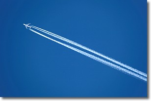
Weather Topic: What are Contrails?
Home - Education - Cloud Types - Contrails
 Next Topic: Cumulonimbus Clouds
A contrail is an artificial cloud, created by the passing of an
aircraft.
Contrails form because water vapor in the exhaust of aircraft engines is suspended
in the air under certain temperatures and humidity conditions. These contrails
are called exhaust contrails.
Another type of contrail can form due to a temporary reduction in air pressure
moving over the plane's surface, causing condensation.
These are called aerodynamic contrails.
When you can see your breath on a cold day, it is also because of condensation.
The reason contrails last longer than the condensation from your breath is
because the water in contrails freezes into ice particles.
Next Topic: Cumulonimbus Clouds
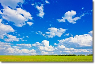
Weather Topic: What are Cumulus Clouds?
Home - Education - Cloud Types - Cumulus Clouds
 Next Topic: Drizzle
Cumulus clouds are fluffy and textured with rounded tops, and
may have flat bottoms. The border of a cumulus cloud
is clearly defined, and can have the appearance of cotton or cauliflower.
Cumulus clouds form at low altitudes (rarely above 2 km) but can grow very tall,
becoming cumulus congestus and possibly the even taller cumulonimbus clouds.
When cumulus clouds become taller, they have a greater chance of producing precipitation.
Next Topic: Drizzle
Current conditions powered by WeatherAPI.com


