Weather Alert in Alaska
Winter Weather Advisory issued March 20 at 1:00PM AKDT until March 22 at 7:00AM AKDT by NWS Juneau AK
AREAS AFFECTED: Petersburg Borough
DESCRIPTION: ...ANOTHER PERIOD OF SNOW FOR THE CENTRAL AND NORTHERN PANHANDLE THIS WEEKEND... .Confidence is increasing on seeing a more significant round of snow this weekend as cold temperatures aloft remain in place and another round of moisture moves in. There remains some uncertainty for snow accumulations at the surface as Saturday afternoon temperatures at sea level are reaching into the mid 30s to around 40 due to increasing daylight and sun angle. However, temperatures aloft are still very favorable for accumulating snow amounts. If the heavier precipitation rates are significant enough to overcome the warmer surface temperatures, snow accumulations will be greater. But if the temperatures are able to overcome the precipitation rates, snowfall will be limited as it melts by the time it reaches the surface. This will need to be monitored for any changes in potential snow accumulation. The orientation of the low and where the showers move into the panhandle will also impact the snow amounts, with how northward and inland the heavier moisture will push and how organized the bands of snow are expected to be when moving through this weekend. Highest snow rates are expected Saturday morning before warmer temperatures in the afternoon begin to limit snow accumulation. * WHAT...Snow expected. Total snow accumulations of 3 to 5 inches. Winds gusting as high as 35 mph. * WHERE...Petersburg Borough. * WHEN...From 7 PM Saturday to 7 AM AKDT Sunday. * IMPACTS...Travel could be difficult. * ADDITIONAL DETAILS...Highest snow rates are expected Saturday evening, especially after temperatures cool after reaching their daytime high Saturday afternoon.
INSTRUCTION: Slow down and use caution while traveling. People are urged to prepare their property before the onset of winter weather. For the latest road conditions, where available, call 5 1 1 or visit 511.alaska.gov.
Want more detail? Get the Complete 7 Day and Night Detailed Forecast!
Current U.S. National Radar--Current
The Current National Weather Radar is shown below with a UTC Time (subtract 5 hours from UTC to get Eastern Time).

National Weather Forecast--Current
The Current National Weather Forecast and National Weather Map are shown below.

National Weather Forecast for Tomorrow
Tomorrow National Weather Forecast and Tomorrow National Weather Map are show below.

North America Water Vapor (Moisture)
This map shows recent moisture content over North America. Bright and colored areas show high moisture (ie, clouds); brown indicates very little moisture present; black indicates no moisture.

Weather Topic: What are Altostratus Clouds?
Home - Education - Cloud Types - Altostratus Clouds
 Next Topic: Cirrocumulus Clouds
Altostratus clouds form at mid to high-level altitudes
(between 2 and 7 km) and are created by a warm, stable air mass which causes
water vapor
to condense as it rise through the atmosphere. Usually altostratus clouds are
featureless sheets characterized by a uniform color.
In some cases, wind punching through the cloud formation may give it a waved
appearance, called altostratus undulatus. Altostratus clouds
are commonly seen with other cloud formations accompanying them.
Next Topic: Cirrocumulus Clouds
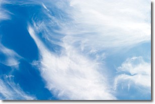
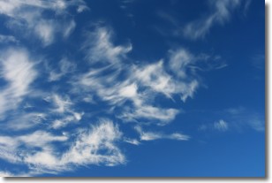
Weather Topic: What are Cirrostratus Clouds?
Home - Education - Cloud Types - Cirrostratus Clouds
 Next Topic: Cirrus Clouds
Cirrostratus clouds are high, thin clouds that form above
20,000 feet and are made mostly of ice crystals. They sometimes look like giant
feathers, horse tails, or curls of hair in the sky.
These clouds are pushed by the jet stream and can move at high speeds reaching
100 mph.
What do they indicate?
They indicate that a precipitation is likely within 24 hours.
Next Topic: Cirrus Clouds
Current conditions powered by WeatherAPI.com


