Weather Alert in Alaska
Wind Advisory issued February 7 at 2:35PM AKST until February 8 at 6:00AM AKST by NWS Juneau AK
AREAS AFFECTED: Municipality of Skagway
DESCRIPTION: * WHAT...Southwest winds 20 to 30 mph with gusts up to 45 mph expected. * WHERE...Municipality of Skagway. * WHEN...From midnight tonight to 6 AM AKST Sunday. * IMPACTS...Gusty winds could blow around unsecured objects. Use extra caution if traveling by land, sea, or air. * ADDITIONAL DETAILS...A quick moving front will bring a swath of strong winds across Skagway through early Sunday morning. Due to the fast moving nature of the front, elevated wind gusts will last for a short duration, peaking shortly after midnight.
INSTRUCTION: Use extra caution when driving, especially if operating a high profile vehicle. Secure outdoor objects.
Want more detail? Get the Complete 7 Day and Night Detailed Forecast!
Current U.S. National Radar--Current
The Current National Weather Radar is shown below with a UTC Time (subtract 5 hours from UTC to get Eastern Time).

National Weather Forecast--Current
The Current National Weather Forecast and National Weather Map are shown below.

National Weather Forecast for Tomorrow
Tomorrow National Weather Forecast and Tomorrow National Weather Map are show below.

North America Water Vapor (Moisture)
This map shows recent moisture content over North America. Bright and colored areas show high moisture (ie, clouds); brown indicates very little moisture present; black indicates no moisture.

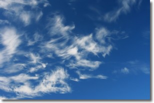
Weather Topic: What are Altostratus Clouds?
Home - Education - Cloud Types - Altostratus Clouds
 Next Topic: Cirrocumulus Clouds
Altostratus clouds form at mid to high-level altitudes
(between 2 and 7 km) and are created by a warm, stable air mass which causes
water vapor
to condense as it rise through the atmosphere. Usually altostratus clouds are
featureless sheets characterized by a uniform color.
In some cases, wind punching through the cloud formation may give it a waved
appearance, called altostratus undulatus. Altostratus clouds
are commonly seen with other cloud formations accompanying them.
Next Topic: Cirrocumulus Clouds
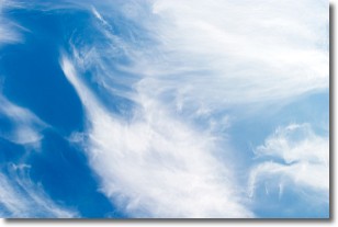
Weather Topic: What are Cirrostratus Clouds?
Home - Education - Cloud Types - Cirrostratus Clouds
 Next Topic: Cirrus Clouds
Cirrostratus clouds are high, thin clouds that form above
20,000 feet and are made mostly of ice crystals. They sometimes look like giant
feathers, horse tails, or curls of hair in the sky.
These clouds are pushed by the jet stream and can move at high speeds reaching
100 mph.
What do they indicate?
They indicate that a precipitation is likely within 24 hours.
Next Topic: Cirrus Clouds
Current conditions powered by WeatherAPI.com


