Weather Alert in Washington
Flood Warning issued March 20 at 6:14PM PDT until March 22 at 5:19PM PDT by NWS Seattle WA
AREAS AFFECTED: Snohomish, WA
DESCRIPTION: ...The Flood Warning is extended for the following rivers in Washington... Snohomish River At Snohomish affecting Snohomish County. * WHAT...Major flooding is occurring and major flooding is forecast. * WHERE...Snohomish River at Snohomish. * WHEN...Until Sunday afternoon. * IMPACTS...At 29.0 feet, the Snohomish River will flood low farm lands and several roads...including Riverview Rd and the Snohomish-Monroe highway. Hide tidal levels could worsen flooding on the lower delta and Ebey Island. Flooding will occur all along the river including headwaters...tributaries...and other streams within and near the Snohomish River Basin. A stage of 29 feet on the Snohomish River corresponds to a Phase 3 in the Snohomish County flood program. * ADDITIONAL DETAILS... - At 6:00 PM PDT Friday the stage was 29.2 feet. - Flood stage is 25.0 feet. - Recent Activity...The maximum river stage in the 24 hours ending at 6:00 PM PDT Friday was 29.2 feet. - Forecast...The river will crest in major flood stage at 30.0 feet late tonight into early Saturday morning. The river will then slowly recede on Saturday, and fall below flood stage Saturday night. - Flood History...This crest compares to a previous crest of 29.9 feet on 11/10/1995. - http://www.weather.gov/safety/flood
INSTRUCTION: Motorists should not attempt to drive around barricades or drive cars through flooded areas. Be especially cautious at night when it is harder to recognize the dangers of flooding. Turn around, don't drown when encountering flooded roads. Most flood deaths occur in vehicles. Caution is urged when walking near riverbanks. Additional information is available at www.weather.gov. The next statement will be issued by late tonight at 215 AM PDT.
Want more detail? Get the Complete 7 Day and Night Detailed Forecast!
Current U.S. National Radar--Current
The Current National Weather Radar is shown below with a UTC Time (subtract 5 hours from UTC to get Eastern Time).

National Weather Forecast--Current
The Current National Weather Forecast and National Weather Map are shown below.

National Weather Forecast for Tomorrow
Tomorrow National Weather Forecast and Tomorrow National Weather Map are show below.

North America Water Vapor (Moisture)
This map shows recent moisture content over North America. Bright and colored areas show high moisture (ie, clouds); brown indicates very little moisture present; black indicates no moisture.

Weather Topic: What is Freezing Rain?
Home - Education - Precipitation - Freezing Rain
 Next Topic: Graupel
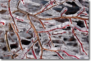
Freezing rain is a condition where precipitation which has fallen in the form of
water droplets reaches temperatures which are below freezing and freezes upon
coming into contact
with surface objects. The result of this precipitation is a glaze of ice which
can be damaging to plants and man-made structures. A severe onset of freezing
rain which results in a very thick glaze of ice is known as an ice storm.
Next Topic: Graupel
Weather Topic: What is Hail?
Home - Education - Precipitation - Hail
 Next Topic: Hole Punch Clouds
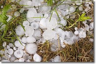
Hail is a form of precipitation which is recognized by large solid balls or
clumps of ice. Hail is created by thunderstorm clouds with strong updrafts of wind.
As the hailstones remain in the updraft, ice is deposited onto them until their
weight becomes heavy enough for them to fall to the earth's surface.
Hail storms can cause significant damage to crops, aircrafts, and man-made structures,
despite the fact that the duration is usually less than ten minutes.
Next Topic: Hole Punch Clouds
Current conditions powered by WeatherAPI.com


