Weather Alert in Colorado
Red Flag Warning issued March 26 at 1:40PM MDT until March 26 at 8:00PM MDT by NWS Pueblo CO
AREAS AFFECTED: Upper Arkansas River Valley Including Lake County and Chaffee County; Fremont County Including Canon City/Howard/Texas Creek; San Luis Valley Including Alamosa/Del Norte/Fort Garland/Saguache; Southern Front Range Including Sangre De Cristo Mountains/Wet Mountains/La Veta Pass; Huerfano County Including Walsenburg; Western Las Animas County Including Trinidad and Thatcher; Eastern Las Animas County Including Pinon Canyon; Baca County Including Springfield and Eastern Comanche Grasslands
DESCRIPTION: ...FIRE WEATHER WATCH IN EFFECT FROM SATURDAY AFTERNOON THROUGH SATURDAY EVENING FOR FIRE WEATHER ZONES 220, 222, 224, 225, 229, 230, 233, AND 237... The National Weather Service in Pueblo has issued a Fire Weather Watch for gusty winds and low relative humidity, which is in effect from Saturday afternoon through Saturday evening. * AFFECTED AREA...Fire Weather Zones 220, 222, 224, 225, 229, 230, 233 and 237. * TIMING...For the Red Flag Warning, until 8 PM MDT this evening. For the Fire Weather Watch, from Saturday afternoon through Saturday evening. * WINDS...For the Red Flag Warning, west-northwest 15 to 25 with gusts to 45 mph. For the Fire Weather Watch, south-southwest 15-25 mph with gusts to 35 mph. * RELATIVE HUMIDITY...As low as 7 percent. * IMPACTS...Elevated fire danger is expected. Fires will catch and spread rapidly and erratically.
INSTRUCTION: A Red Flag Warning means that critical fire weather conditions are either occurring now, or will shortly. A combination of strong winds, low relative humidity, and warm temperatures can contribute to extreme fire behavior. A Fire Weather Watch means that critical fire weather conditions are forecast to occur. Listen for later forecasts and possible Red Flag Warnings.
Want more detail? Get the Complete 7 Day and Night Detailed Forecast!
Current U.S. National Radar--Current
The Current National Weather Radar is shown below with a UTC Time (subtract 5 hours from UTC to get Eastern Time).

National Weather Forecast--Current
The Current National Weather Forecast and National Weather Map are shown below.

National Weather Forecast for Tomorrow
Tomorrow National Weather Forecast and Tomorrow National Weather Map are show below.

North America Water Vapor (Moisture)
This map shows recent moisture content over North America. Bright and colored areas show high moisture (ie, clouds); brown indicates very little moisture present; black indicates no moisture.

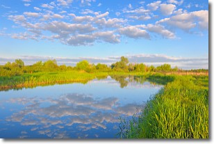
Weather Topic: What are Stratocumulus Clouds?
Home - Education - Cloud Types - Stratocumulus Clouds
 Next Topic: Stratus Clouds
Stratocumulus clouds are similar to altocumulus clouds in their
fluffy appearance, but have a slightly darker shade due to their additional mass.
A good way to distinguish the two cloud types is to hold your hand out and measure
the size of an individual cloud; if it is the size of your thumb it is generally
an altocumulus cloud, if it is the size of your hand it is generally a
stratocumulus cloud.
It is uncommon for stratocumulus clouds to produce precipitation, but if they do
it is usually a light rain or snow.
Next Topic: Stratus Clouds
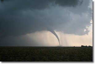
Weather Topic: What are Wall Clouds?
Home - Education - Cloud Types - Wall Clouds
 Next Topic: Altocumulus Clouds
A wall cloud forms underneath the base of a cumulonimbus cloud,
and can be a hotbed for deadly tornadoes.
Wall clouds are formed by air flowing into the cumulonimbus clouds, which can
result in the wall cloud descending from the base of the cumulonimbus cloud, or
rising fractus clouds which join to the base of the storm cloud as the wall cloud
takes shape.
Wall clouds can be very large, and in the Northern Hemisphere they generally
form at the southern edge of cumulonimbus clouds.
Next Topic: Altocumulus Clouds
Current conditions powered by WeatherAPI.com


