Weather Alert in Colorado
Fire Weather Watch issued March 26 at 1:40PM MDT until March 28 at 7:00PM MDT by NWS Pueblo CO
AREAS AFFECTED: Upper Arkansas River Valley Including Lake County and Chaffee County; Fremont County Including Canon City/Howard/Texas Creek; San Luis Valley Including Alamosa/Del Norte/Fort Garland/Saguache; Southern Front Range Including Sangre De Cristo Mountains/Wet Mountains/La Veta Pass; Huerfano County Including Walsenburg; Western Las Animas County Including Trinidad and Thatcher; Eastern Las Animas County Including Pinon Canyon; Baca County Including Springfield and Eastern Comanche Grasslands
DESCRIPTION: ...FIRE WEATHER WATCH IN EFFECT FROM SATURDAY AFTERNOON THROUGH SATURDAY EVENING FOR FIRE WEATHER ZONES 220, 222, 224, 225, 229, 230, 233, AND 237... The National Weather Service in Pueblo has issued a Fire Weather Watch for gusty winds and low relative humidity, which is in effect from Saturday afternoon through Saturday evening. * AFFECTED AREA...Fire Weather Zones 220, 222, 224, 225, 229, 230, 233 and 237. * TIMING...For the Red Flag Warning, until 8 PM MDT this evening. For the Fire Weather Watch, from Saturday afternoon through Saturday evening. * WINDS...For the Red Flag Warning, west-northwest 15 to 25 with gusts to 45 mph. For the Fire Weather Watch, south-southwest 15-25 mph with gusts to 35 mph. * RELATIVE HUMIDITY...As low as 7 percent. * IMPACTS...Elevated fire danger is expected. Fires will catch and spread rapidly and erratically.
INSTRUCTION: A Red Flag Warning means that critical fire weather conditions are either occurring now, or will shortly. A combination of strong winds, low relative humidity, and warm temperatures can contribute to extreme fire behavior. A Fire Weather Watch means that critical fire weather conditions are forecast to occur. Listen for later forecasts and possible Red Flag Warnings.
Want more detail? Get the Complete 7 Day and Night Detailed Forecast!
Current U.S. National Radar--Current
The Current National Weather Radar is shown below with a UTC Time (subtract 5 hours from UTC to get Eastern Time).

National Weather Forecast--Current
The Current National Weather Forecast and National Weather Map are shown below.

National Weather Forecast for Tomorrow
Tomorrow National Weather Forecast and Tomorrow National Weather Map are show below.

North America Water Vapor (Moisture)
This map shows recent moisture content over North America. Bright and colored areas show high moisture (ie, clouds); brown indicates very little moisture present; black indicates no moisture.

Weather Topic: What is Freezing Rain?
Home - Education - Precipitation - Freezing Rain
 Next Topic: Graupel
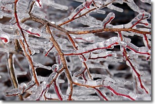
Freezing rain is a condition where precipitation which has fallen in the form of
water droplets reaches temperatures which are below freezing and freezes upon
coming into contact
with surface objects. The result of this precipitation is a glaze of ice which
can be damaging to plants and man-made structures. A severe onset of freezing
rain which results in a very thick glaze of ice is known as an ice storm.
Next Topic: Graupel
Weather Topic: What is Hail?
Home - Education - Precipitation - Hail
 Next Topic: Hole Punch Clouds
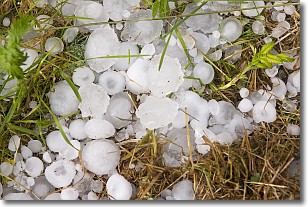
Hail is a form of precipitation which is recognized by large solid balls or
clumps of ice. Hail is created by thunderstorm clouds with strong updrafts of wind.
As the hailstones remain in the updraft, ice is deposited onto them until their
weight becomes heavy enough for them to fall to the earth's surface.
Hail storms can cause significant damage to crops, aircrafts, and man-made structures,
despite the fact that the duration is usually less than ten minutes.
Next Topic: Hole Punch Clouds
Current conditions powered by WeatherAPI.com


