Weather Alert in Alaska
Flood Warning issued August 31 at 9:26PM AKDT until September 1 at 12:00PM AKDT by NWS Fairbanks AK
AREAS AFFECTED: Upper Koyukuk Valley
DESCRIPTION: * WHAT...Flooding caused by excessive rainfall continues. * WHERE...Koyukuk River near Allakaket. * WHEN...Until noon AKDT Monday. * IMPACTS...Flooding of rivers, creeks, streams, and other low-lying and flood-prone locations is occurring. * ADDITIONAL DETAILS... - Since Wednesday the Koyukuk River has been inundating roads in downtown Allakaket - River levels appear to have stabilized, but inundation of low lying roads is expected to continue. The streamgage on the Koyukuk River below the John River has shown over a foot of water level drop in the last 12 hours. The Middle and South Forks of the Koyukuk are also showing decreasing water levels. Water levels at Allakaket should start showing a slow recession tonight. This is encouraging as over an inch of rain is forecast for the south slopes of the Brooks Range through Tuesday. For context, the highest water levels from this event are about 7 ft lower in Allakaket than the 1994 flood. - Low lying roads are currently flooded and airport access may be cut off. - http://www.weather.gov/aprfc
INSTRUCTION: N/A
Want more detail? Get the Complete 7 Day and Night Detailed Forecast!
Current U.S. National Radar--Current
The Current National Weather Radar is shown below with a UTC Time (subtract 5 hours from UTC to get Eastern Time).

National Weather Forecast--Current
The Current National Weather Forecast and National Weather Map are shown below.

National Weather Forecast for Tomorrow
Tomorrow National Weather Forecast and Tomorrow National Weather Map are show below.

North America Water Vapor (Moisture)
This map shows recent moisture content over North America. Bright and colored areas show high moisture (ie, clouds); brown indicates very little moisture present; black indicates no moisture.

Weather Topic: What are Stratus Clouds?
Home - Education - Cloud Types - Stratus Clouds
 Next Topic: Wall Clouds
Stratus clouds are similar to altostratus clouds, but form at a
lower altitude and are identified by their fog-like appearance, lacking the
distinguishing features of most clouds.
Stratus clouds are wider than most clouds, and their base has a smooth, uniform
look which is lighter in color than a nimbostratus cloud.
The presence of a stratus cloud indicates the possibility of minor precipitation,
such as drizzle, but heavier precipitation does not typically arrive in the form
of a stratus cloud.
Next Topic: Wall Clouds
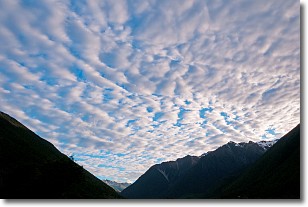
Weather Topic: What are Altocumulus Clouds?
Home - Education - Cloud Types - Altocumulus Clouds
 Next Topic: Altostratus Clouds
Similar to cirrocumulus clouds, altocumulus clouds are
characterized by cloud patches. They are distinguished by larger cloudlets
than cirrocumulus clouds but are still smaller than stratocumulus clouds.
Altocumulus clouds most commonly form in middle altitudes (between 2 and 5 km)
and may resemble, at times, the shape of a flying saucer.
These uncommon formations, called altocumulus lenticularis, are created by uplift
in the atmosphere and are most often seen in close proximity to mountains.
Next Topic: Altostratus Clouds
Current conditions powered by WeatherAPI.com


