Weather Alert in California
Air Quality Alert issued September 3 at 4:06PM PDT by NWS Hanford CA
AREAS AFFECTED: Fresno, CA; Kern, CA; Kings, CA; Madera, CA; Merced, CA; San Joaquin, CA; Stanislaus, CA; Tulare, CA
DESCRIPTION: The Valley Air District is issuing an Air Quality Alert on September 3, 2025, due to smoke impacts from wildfires in California including the Garnet Fire, the Marmon Fire, the Salt 11-2 Fire, and the TCU September Lightning Complex for San Joaquin, Stanislaus, Merced, Madera, Fresno, Kings, Tulare, and the Valley portion of Kern Counties. This Air Quality Alert is in effect until the fires are extinguished. Exposure to particle pollution can cause serious health problems, aggravate lung disease, cause asthma attacks and acute bronchitis, and increase risk of respiratory infections. Residents are advised to use caution as conditions warrant. People with heart or lung diseases should follow their doctors advice for dealing with episodes of unhealthy air quality. Additionally, older adults and children should avoid prolonged exposure, strenuous activities or heavy exertion, as conditions dictate. For additional information, call your local San Joaquin Valley Air District office. Modesto 209-557-6400, Fresno 559-230-6000, Bakersfield 661-392-5500 Residents can also follow air quality conditions by downloading the free Valley Air app, available in the Apple store or Google Play.
INSTRUCTION: N/A
Want more detail? Get the Complete 7 Day and Night Detailed Forecast!
Current U.S. National Radar--Current
The Current National Weather Radar is shown below with a UTC Time (subtract 5 hours from UTC to get Eastern Time).

National Weather Forecast--Current
The Current National Weather Forecast and National Weather Map are shown below.

National Weather Forecast for Tomorrow
Tomorrow National Weather Forecast and Tomorrow National Weather Map are show below.

North America Water Vapor (Moisture)
This map shows recent moisture content over North America. Bright and colored areas show high moisture (ie, clouds); brown indicates very little moisture present; black indicates no moisture.

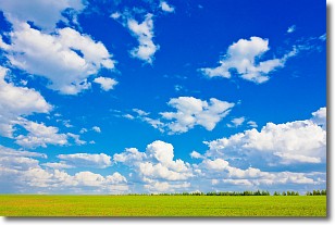
Weather Topic: What are Cumulus Clouds?
Home - Education - Cloud Types - Cumulus Clouds
 Next Topic: Drizzle
Cumulus clouds are fluffy and textured with rounded tops, and
may have flat bottoms. The border of a cumulus cloud
is clearly defined, and can have the appearance of cotton or cauliflower.
Cumulus clouds form at low altitudes (rarely above 2 km) but can grow very tall,
becoming cumulus congestus and possibly the even taller cumulonimbus clouds.
When cumulus clouds become taller, they have a greater chance of producing precipitation.
Next Topic: Drizzle
Weather Topic: What is Evaporation?
Home - Education - Precipitation - Evaporation
 Next Topic: Fog
Evaporation is the process which returns water from the earth
back to the atmosphere, and is another crucial process in the water cycle.
Evaporation is the transformation of liquid into gas, and it happens because
molecules are excited by the application of energy and turn into vapor.
In order for water to evaporate it has to be on the surface of a body of water.
Next Topic: Fog
Current conditions powered by WeatherAPI.com


