Weather Alert in Washington
Extreme Heat Warning issued August 22 at 2:46AM PDT until August 26 at 5:00AM PDT by NWS Seattle WA
AREAS AFFECTED: Foothills and Valleys of the North Cascades; Foothills and Valleys of Snohomish and Northern King Counties; Foothills and Valleys of Central King County; Foothills and Valleys of Pierce and Southern King Counties; Foothills and Valleys of Thurston and Lewis Counties
DESCRIPTION: * WHAT...Hot conditions with high temperatures ranging from the upper 80s to upper 90s and low temperatures mostly in the 60s. This will pose a major risk of heat-related illness. * WHERE...Foothills and Valleys of the North Cascades, Foothills and Valleys of Central King County, Foothills and Valleys of Pierce and Southern King Counties, Foothills and Valleys of Snohomish and Northern King Counties, and Foothills and Valleys of Thurston and Lewis Counties. * WHEN...From 11 AM this morning to 5 AM PDT Tuesday. * IMPACTS...Heat related illnesses increase significantly during extreme heat events.
INSTRUCTION: Drink plenty of fluids, stay in an air-conditioned room, stay out of the sun, and check up on relatives and neighbors. Young children and pets should never be left unattended in vehicles under any circumstances. Take extra precautions if you work or spend time outside. When possible reschedule strenuous activities to early morning or evening. Know the signs and symptoms of heat exhaustion and heat stroke. Wear lightweight and loose fitting clothing when possible. To reduce risk during outdoor work, the Occupational Safety and Health Administration recommends scheduling frequent rest breaks in shaded or air conditioned environments. Anyone overcome by heat should be moved to a cool and shaded location. Heat stroke is an emergency! Call 9 1 1. For sheltering information and other human services in your area, dial 2 1 1 during business hours or visit wa211.org anytime.
Want more detail? Get the Complete 7 Day and Night Detailed Forecast!
Current U.S. National Radar--Current
The Current National Weather Radar is shown below with a UTC Time (subtract 5 hours from UTC to get Eastern Time).

National Weather Forecast--Current
The Current National Weather Forecast and National Weather Map are shown below.

National Weather Forecast for Tomorrow
Tomorrow National Weather Forecast and Tomorrow National Weather Map are show below.

North America Water Vapor (Moisture)
This map shows recent moisture content over North America. Bright and colored areas show high moisture (ie, clouds); brown indicates very little moisture present; black indicates no moisture.

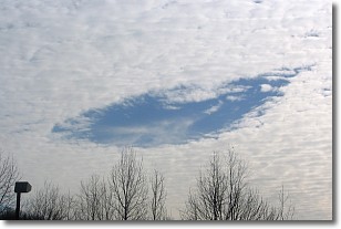
Weather Topic: What are Hole Punch Clouds?
Home - Education - Cloud Types - Hole Punch Clouds
 Next Topic: Mammatus Clouds
A hole punch cloud is an unusual occurrence when a disk-shaped
hole appears in a cirrostratus, cirrocumulus, or altocumulus cloud.
When part of the cloud forms ice crystals, water droplets in the surrounding area
of the cloud evaporate. The effect of this process produces a large elliptical
gap in the cloud. The hole punch cloud formation is rare, but it is not specific
to any geographic area.
Other names which have been used to describe this phenomena include fallstreak hole,
skypunch, and cloud hole.
Next Topic: Mammatus Clouds
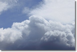
Weather Topic: What are Nimbostratus Clouds?
Home - Education - Cloud Types - Nimbostratus Clouds
 Next Topic: Precipitation
A nimbostratus cloud is similar to a stratus cloud in its formless,
smooth appearance. However, a nimbostratus cloud is darker than a stratus cloud,
because it is thicker.
Unlike a stratus cloud, a nimbostratus cloud typically brings with it the threat
of moderate to heavy precipitation. In some cases, the precipitation may evaporate
before reaching the ground, a phenomenon known as virga.
Next Topic: Precipitation
Current conditions powered by WeatherAPI.com


