Weather Alert in North Carolina
Beach Hazards Statement issued August 21 at 3:30AM EDT until August 21 at 8:00PM EDT by NWS Newport/Morehead City NC
AREAS AFFECTED: Northern Outer Banks; Ocracoke Island; Hatteras Island
DESCRIPTION: * WHAT...For the High Surf Advisory, large breaking waves of 7 to 17 feet in the surf zone. For the Beach Hazards Statement, dangerous rip currents. * WHERE...The beaches from Duck to Ocracoke. * WHEN...For the High Surf Advisory, until midnight EDT Friday night. For the Beach Hazards Statement, through this evening. * IMPACTS...Extreme beach and coastal damage is likely along the oceanside, resulting in a significant threat to life and property. Large dangerous waves will likely inundate and destroy protective dune structures. Severe flooding will likely extend inland from the waterfront causing flooding of many homes and businesses with some structural damage possible. Numerous roads will likely be impassable under several feet of water and vehicles will likely be submerged. Actions will need to be taken to protect life and property. Extremely dangerous swimming and surfing conditions expected, as well as the wave action resulting in significant beach erosion. * ADDITIONAL DETAILS...Minor soundside inundation is possible on the Outer Banks from Buxton to Ocracoke due to the increase in north winds today. Water level rises of 1 to 2 feet are possible here through this evening.
INSTRUCTION: Take the necessary actions to protect flood-prone property. If travel is required, do not drive around barricades or through water of unknown depth. The surf will be extremely dangerous for everyone, and swimming is absolutely discouraged.
Want more detail? Get the Complete 7 Day and Night Detailed Forecast!
Current U.S. National Radar--Current
The Current National Weather Radar is shown below with a UTC Time (subtract 5 hours from UTC to get Eastern Time).

National Weather Forecast--Current
The Current National Weather Forecast and National Weather Map are shown below.

National Weather Forecast for Tomorrow
Tomorrow National Weather Forecast and Tomorrow National Weather Map are show below.

North America Water Vapor (Moisture)
This map shows recent moisture content over North America. Bright and colored areas show high moisture (ie, clouds); brown indicates very little moisture present; black indicates no moisture.

Weather Topic: What is Graupel?
Home - Education - Precipitation - Graupel
 Next Topic: Hail
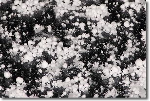
Graupel is a form of precipitation that is created by atmospheric conditions
which cause supercooled water droplets to contact snow crystals and freeze to
their surface.
Sometimes known as soft hail or snow pellets, graupel is delicate and easily
destroyed by touch. Whereas hail usually falls during severe weather, graupel
doesn't require such conditions to form, and can form in mild precipitation
similar to situations which produce snowfall.
Next Topic: Hail
Weather Topic: What are Hole Punch Clouds?
Home - Education - Cloud Types - Hole Punch Clouds
 Next Topic: Mammatus Clouds
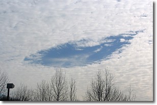
A hole punch cloud is an unusual occurrence when a disk-shaped
hole appears in a cirrostratus, cirrocumulus, or altocumulus cloud.
When part of the cloud forms ice crystals, water droplets in the surrounding area
of the cloud evaporate. The effect of this process produces a large elliptical
gap in the cloud. The hole punch cloud formation is rare, but it is not specific
to any geographic area.
Other names which have been used to describe this phenomena include fallstreak hole,
skypunch, and cloud hole.
Next Topic: Mammatus Clouds
Current conditions powered by WeatherAPI.com


