Weather Alert in North Carolina
High Surf Advisory issued August 21 at 3:30AM EDT until August 23 at 12:00AM EDT by NWS Newport/Morehead City NC
AREAS AFFECTED: Northern Outer Banks; Ocracoke Island; Hatteras Island
DESCRIPTION: * WHAT...For the High Surf Advisory, large breaking waves of 7 to 17 feet in the surf zone. For the Beach Hazards Statement, dangerous rip currents. * WHERE...The beaches from Duck to Ocracoke. * WHEN...For the High Surf Advisory, until midnight EDT Friday night. For the Beach Hazards Statement, through this evening. * IMPACTS...Extreme beach and coastal damage is likely along the oceanside, resulting in a significant threat to life and property. Large dangerous waves will likely inundate and destroy protective dune structures. Severe flooding will likely extend inland from the waterfront causing flooding of many homes and businesses with some structural damage possible. Numerous roads will likely be impassable under several feet of water and vehicles will likely be submerged. Actions will need to be taken to protect life and property. Extremely dangerous swimming and surfing conditions expected, as well as the wave action resulting in significant beach erosion. * ADDITIONAL DETAILS...Minor soundside inundation is possible on the Outer Banks from Buxton to Ocracoke due to the increase in north winds today. Water level rises of 1 to 2 feet are possible here through this evening.
INSTRUCTION: Take the necessary actions to protect flood-prone property. If travel is required, do not drive around barricades or through water of unknown depth. The surf will be extremely dangerous for everyone, and swimming is absolutely discouraged.
Want more detail? Get the Complete 7 Day and Night Detailed Forecast!
Current U.S. National Radar--Current
The Current National Weather Radar is shown below with a UTC Time (subtract 5 hours from UTC to get Eastern Time).

National Weather Forecast--Current
The Current National Weather Forecast and National Weather Map are shown below.

National Weather Forecast for Tomorrow
Tomorrow National Weather Forecast and Tomorrow National Weather Map are show below.

North America Water Vapor (Moisture)
This map shows recent moisture content over North America. Bright and colored areas show high moisture (ie, clouds); brown indicates very little moisture present; black indicates no moisture.

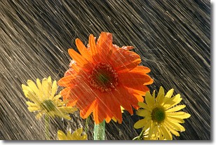
Weather Topic: What is Precipitation?
Home - Education - Precipitation - Precipitation
 Next Topic: Rain
Precipitation can refer to many different forms of water that
may fall from clouds. Precipitation occurs after a cloud has become saturated to
the point where its water particles are more dense than the air below the cloud.
In most cases, precipitation will reach the ground, but it is not uncommon for
precipitation to evaporate before it reaches the earth's surface.
When precipitation evaporates before it contacts the ground it is called Virga.
Graupel, hail, sleet, rain, drizzle, and snow are forms of precipitation, but fog
and mist are not considered precipitation because the water vapor which
constitutes them isn't dense enough to fall to the ground.
Next Topic: Rain
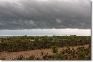
Weather Topic: What are Shelf Clouds?
Home - Education - Cloud Types - Shelf Clouds
 Next Topic: Sleet
A shelf cloud is similar to a wall cloud, but forms at the front
of a storm cloud, instead of at the rear, where wall clouds form.
A shelf cloud is caused by a series of events set into motion by the advancing
storm; first, cool air settles along the ground where precipitation has just fallen.
As the cool air is brought in, the warmer air is displaced, and rises above it,
because it is less dense. When the warmer air reaches the bottom of the storm cloud,
it begins to cool again, and the resulting condensation is a visible shelf cloud.
Next Topic: Sleet
Current conditions powered by WeatherAPI.com


