Weather Alert in Kansas
Red Flag Warning issued March 20 at 1:47PM CDT until March 22 at 4:00AM CDT by NWS Hastings NE
AREAS AFFECTED: Phillips; Smith; Jewell; Rooks; Osborne; Mitchell; Valley; Greeley; Nance; Sherman; Howard; Merrick; Polk; Dawson; Buffalo; Hall; Hamilton; York; Gosper; Phelps; Kearney; Adams; Clay; Fillmore; Furnas; Harlan; Franklin; Webster; Nuckolls; Thayer
DESCRIPTION: ...Critical Fire Weather Conditions Saturday into Early Sunday Morning... * WINDS...On Saturday into Saturday evening, out of the south to southwest...sustained 10 to 20 MPH and gusting 20 to 30 MPH. After midnight Saturday night into early Sunday morning, abruptly turning northerly behind a strong cold front and gusting at least 40 to 50 MPH. * RELATIVE HUMIDITY...As low as 5 to 15 percent on Saturday afternoon, then increasing to 30 to 50 percent by the time the Warning expires early Sunday morning. * IMPACTS...Any fire that develops will spread quickly. Outdoor burning is not recommended. * ADDITIONAL DETAILS...Although winds on Saturday will not be overly-strong with gusts mainly under 30 MPH, record-breaking heat and very low relative humidity will nonetheless promote dangerous fire weather conditions. Adding to the concern, any fires that might start on Saturday will then be subject to a sharp/abrupt shift to strong northerly winds early Sunday morning behind a surging cold front.
INSTRUCTION: A Red Flag Warning means that critical fire weather conditions are either occurring now, or will shortly. A combination of strong winds, low relative humidity, and warm temperatures can contribute to extreme fire behavior.
Want more detail? Get the Complete 7 Day and Night Detailed Forecast!
Current U.S. National Radar--Current
The Current National Weather Radar is shown below with a UTC Time (subtract 5 hours from UTC to get Eastern Time).

National Weather Forecast--Current
The Current National Weather Forecast and National Weather Map are shown below.

National Weather Forecast for Tomorrow
Tomorrow National Weather Forecast and Tomorrow National Weather Map are show below.

North America Water Vapor (Moisture)
This map shows recent moisture content over North America. Bright and colored areas show high moisture (ie, clouds); brown indicates very little moisture present; black indicates no moisture.

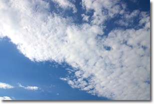
Weather Topic: What are Altocumulus Clouds?
Home - Education - Cloud Types - Altocumulus Clouds
 Next Topic: Altostratus Clouds
Similar to cirrocumulus clouds, altocumulus clouds are
characterized by cloud patches. They are distinguished by larger cloudlets
than cirrocumulus clouds but are still smaller than stratocumulus clouds.
Altocumulus clouds most commonly form in middle altitudes (between 2 and 5 km)
and may resemble, at times, the shape of a flying saucer.
These uncommon formations, called altocumulus lenticularis, are created by uplift
in the atmosphere and are most often seen in close proximity to mountains.
Next Topic: Altostratus Clouds
Weather Topic: What are Cirrocumulus Clouds?
Home - Education - Cloud Types - Cirrocumulus Clouds
 Next Topic: Cirrostratus Clouds
Cirrocumulus clouds form at high altitudes (usually around 5 km)
and have distinguishing characteristics displayed in a fine layer of
small cloud patches. These small cloud patches are sometimes referred to as
"cloudlets" in relation to the whole cloud formation.
Cirrocumulus clouds are formed from ice crystals and water droplets. Often, the
water droplets in the cloud freeze into ice crystals and the cloud becomes a
cirrostratus cloud. Because of this common occurrence, cirrocumulus cloud
formations generally pass rapidly.
Next Topic: Cirrostratus Clouds
Current conditions powered by WeatherAPI.com


