Weather Alert in Alabama
Fire Weather Watch issued March 26 at 10:32PM CDT until March 28 at 7:00PM CDT by NWS Huntsville AL
AREAS AFFECTED: Lauderdale; Colbert; Franklin; Lawrence; Limestone; Madison; Morgan; Marshall; Jackson; DeKalb; Winston; Cullman
DESCRIPTION: ...Fire Weather Watch in Effect Saturday 7 AM until 7 PM For All of North Alabama... * AFFECTED AREA...Fire Weather Zone 001 Lauderdale, Fire Weather Zone 002 Colbert, Fire Weather Zone 003 Franklin AL, Fire Weather Zone 004 Lawrence, Fire Weather Zone 005 Limestone, Fire Weather Zone 006 Madison, Fire Weather Zone 007 Morgan, Fire Weather Zone 008 Marshall, Fire Weather Zone 009 Jackson, Fire Weather Zone 010 DeKalb, Fire Weather Zone 014 Winston and Fire Weather Zone 016 Cullman. * WINDS...Northeast 15-20 mph with gusts up to 30-35 mph. * RELATIVE HUMIDITY...As low as 20 percent. * IMPACTS...Any fires that develop will likely spread rapidly. Please obey any local burn bans that are in place!
INSTRUCTION: A Fire Weather Watch means that critical fire weather conditions are forecast to occur. Listen for later forecasts and possible Red Flag Warnings.
Want more detail? Get the Complete 7 Day and Night Detailed Forecast!
Current U.S. National Radar--Current
The Current National Weather Radar is shown below with a UTC Time (subtract 5 hours from UTC to get Eastern Time).

National Weather Forecast--Current
The Current National Weather Forecast and National Weather Map are shown below.

National Weather Forecast for Tomorrow
Tomorrow National Weather Forecast and Tomorrow National Weather Map are show below.

North America Water Vapor (Moisture)
This map shows recent moisture content over North America. Bright and colored areas show high moisture (ie, clouds); brown indicates very little moisture present; black indicates no moisture.

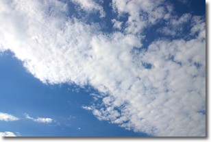
Weather Topic: What are Stratus Clouds?
Home - Education - Cloud Types - Stratus Clouds
 Next Topic: Wall Clouds
Stratus clouds are similar to altostratus clouds, but form at a
lower altitude and are identified by their fog-like appearance, lacking the
distinguishing features of most clouds.
Stratus clouds are wider than most clouds, and their base has a smooth, uniform
look which is lighter in color than a nimbostratus cloud.
The presence of a stratus cloud indicates the possibility of minor precipitation,
such as drizzle, but heavier precipitation does not typically arrive in the form
of a stratus cloud.
Next Topic: Wall Clouds
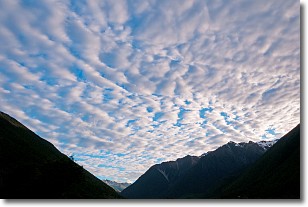
Weather Topic: What are Altocumulus Clouds?
Home - Education - Cloud Types - Altocumulus Clouds
 Next Topic: Altostratus Clouds
Similar to cirrocumulus clouds, altocumulus clouds are
characterized by cloud patches. They are distinguished by larger cloudlets
than cirrocumulus clouds but are still smaller than stratocumulus clouds.
Altocumulus clouds most commonly form in middle altitudes (between 2 and 5 km)
and may resemble, at times, the shape of a flying saucer.
These uncommon formations, called altocumulus lenticularis, are created by uplift
in the atmosphere and are most often seen in close proximity to mountains.
Next Topic: Altostratus Clouds
Current conditions powered by WeatherAPI.com


