Weather Alert in California
Flash Flood Warning issued September 10 at 3:25PM PDT until September 10 at 6:00PM PDT by NWS Sacramento CA
AREAS AFFECTED: Tehama, CA
DESCRIPTION: At 325 PM PDT, Doppler radar indicated thunderstorms producing heavy rain over the Tehama County Division of the Park Fire Burn Scar. The expected rainfall rate is 0.5 to 1 inch in 1 hour. Flash flooding is ongoing or expected to begin shortly. Excessive rainfall over the warning area will cause mud slides near steep terrain. The mud slide can consist of rock, mud, vegetation and other loose materials. HAZARD...Life threatening flash flooding. Thunderstorms producing flash flooding in and around the Tehama County Division of the Park Fire Burn Scar. SOURCE...Radar. IMPACT...Life threatening flash flooding of areas in and around the Tehama County Division of the Park Fire Burn Scar. Some locations that will experience flash flooding include... Mineral, Paynes Creek and Manton. * Additional locations include... Highway 36 corridor, Paynes Creek, Mill Creek, Deer Creek, and Pine Creek
INSTRUCTION: Move away from recently burned areas. Life-threatening flooding of creeks, roads and normally dry areas is likely. The heavy rains will likely trigger rockslides, mudslides and debris flows in steep terrain, especially in and around these areas. Turn around, don't drown when encountering flooded roads. Most flood deaths occur in vehicles. This is a life threatening situation. Heavy rainfall will cause extensive and severe flash flooding of creeks...streams...and ditches in the Tehama County Division of the Park Fire Burn Scar. Severe debris flows can also be anticipated across roads. Roads and driveways may be washed away in places. If you encounter flood waters...climb to safety.
Want more detail? Get the Complete 7 Day and Night Detailed Forecast!
Current U.S. National Radar--Current
The Current National Weather Radar is shown below with a UTC Time (subtract 5 hours from UTC to get Eastern Time).

National Weather Forecast--Current
The Current National Weather Forecast and National Weather Map are shown below.

National Weather Forecast for Tomorrow
Tomorrow National Weather Forecast and Tomorrow National Weather Map are show below.

North America Water Vapor (Moisture)
This map shows recent moisture content over North America. Bright and colored areas show high moisture (ie, clouds); brown indicates very little moisture present; black indicates no moisture.

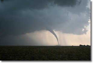
Weather Topic: What are Wall Clouds?
Home - Education - Cloud Types - Wall Clouds
 Next Topic: Altocumulus Clouds
A wall cloud forms underneath the base of a cumulonimbus cloud,
and can be a hotbed for deadly tornadoes.
Wall clouds are formed by air flowing into the cumulonimbus clouds, which can
result in the wall cloud descending from the base of the cumulonimbus cloud, or
rising fractus clouds which join to the base of the storm cloud as the wall cloud
takes shape.
Wall clouds can be very large, and in the Northern Hemisphere they generally
form at the southern edge of cumulonimbus clouds.
Next Topic: Altocumulus Clouds
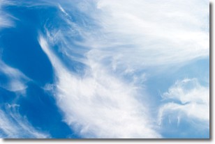
Weather Topic: What are Altostratus Clouds?
Home - Education - Cloud Types - Altostratus Clouds
 Next Topic: Cirrocumulus Clouds
Altostratus clouds form at mid to high-level altitudes
(between 2 and 7 km) and are created by a warm, stable air mass which causes
water vapor
to condense as it rise through the atmosphere. Usually altostratus clouds are
featureless sheets characterized by a uniform color.
In some cases, wind punching through the cloud formation may give it a waved
appearance, called altostratus undulatus. Altostratus clouds
are commonly seen with other cloud formations accompanying them.
Next Topic: Cirrocumulus Clouds
Current conditions powered by WeatherAPI.com


