Weather Alert in Washington
Fire Weather Watch issued August 23 at 5:53AM PDT until August 26 at 9:00PM PDT by NWS Spokane WA
AREAS AFFECTED: East Washington Central Cascades; East Portion of North Cascades National Park / Lake Chelan National Recreation Area; East Washington North Cascades; Methow Valley
DESCRIPTION: ...HOT, DRY, AND UNSTABLE CONDITIONS FOR MONDAY AND TUESDAY... .A strong ridge of high pressure will bring a period of hot and dry conditions to the central and northern Cascades of Washington this weekend. The ridge will shift east of the Cascades early next week with the atmosphere becoming more unstable at that time. Increased instability with hot and dry conditions will bring the potential for critical fire weather conditions. * Affected Area: East Washington Central Cascades (Zone 696), East Portion of North Cascades National Park/Lake Chelan National Recreation Area (Zone 697), East Washington North Cascades (Zone 698) and Methow Valley (Zone 704). * Winds: East-southeast 3 to 7 mph in the afternoon becoming west 5 to 10 mph in the evening. * Timing: Afternoon and evening for both Monday and Tuesday. * Relative Humidities: Below 4,000 feet: 13 to 20 percent. Above 4,000 feet: 20 to 30 percent. * Temperatures: Below 4,000 feet: 90 to 102 degrees. Above 4,000 feet: 75 to 90 degrees. * Impacts: Hot, dry, and unstable conditions may lead to rapid fire growth on any new or existing fires.
INSTRUCTION: A Fire Weather Watch means that critical fire weather conditions are forecast to occur. Listen for later forecasts and possible Red Flag Warnings.
Want more detail? Get the Complete 7 Day and Night Detailed Forecast!
Current U.S. National Radar--Current
The Current National Weather Radar is shown below with a UTC Time (subtract 5 hours from UTC to get Eastern Time).

National Weather Forecast--Current
The Current National Weather Forecast and National Weather Map are shown below.

National Weather Forecast for Tomorrow
Tomorrow National Weather Forecast and Tomorrow National Weather Map are show below.

North America Water Vapor (Moisture)
This map shows recent moisture content over North America. Bright and colored areas show high moisture (ie, clouds); brown indicates very little moisture present; black indicates no moisture.

Weather Topic: What is Drizzle?
Home - Education - Precipitation - Drizzle
 Next Topic: Evaporation
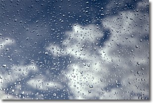
Drizzle is precipitation in the form of water droplets which are
smaller than raindrops.
Drizzle is characterized by fine, gently falling droplets and typically does not
impact human habitation in a negative way. The exception to this is freezing drizzle,
a condition where drizzle freezes immediately upon reaching earth's surface.
Freezing drizzle is still less dangerous than freezing rain, but can
potentially result in hazardous road conditions.
Next Topic: Evaporation
Weather Topic: What is Fog?
Home - Education - Cloud Types - Fog
 Next Topic: Fractus Clouds
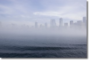
Fog is technically a type of stratus cloud, which lies along the
ground and obscures visibility.
It is usually created when humidity in the air condenses into tiny water droplets.
Because of this, some places are more prone to foggy weather, such as regions
close to a body of water.
Fog is similar to mist; both are the appearance of water droplets suspended in
the air, but fog is the term applied to the condition when visibility is less than 1 km.
Next Topic: Fractus Clouds
Current conditions powered by WeatherAPI.com


