Weather Alert in Alaska
High Wind Warning issued August 28 at 9:58PM AKDT until August 29 at 2:00AM AKDT by NWS Anchorage AK
AREAS AFFECTED: Anchorage
DESCRIPTION: * WHAT...Southeast winds 20 to 30 mph with gusts up to 55 mph. * WHERE...Anchorage. * WHEN...Until 2 AM AKDT Friday. * IMPACTS...High winds may move loose debris, damage property, and cause power outages. Trees are still fully leafed, and will be particularly vulnerable to damage in strong winds. Travel could be difficult, especially for high profile vehicles. * ADDITIONAL DETAILS...The strongest winds have likely already peaked, but a few gusts as strong as 40 to 55 mph will remain possible across the Anchorage bowl over the next few hours. The strongest winds will slowly diminish early Friday morning.
INSTRUCTION: People are urged to secure loose objects that could be blown around or damaged by the wind. Prepare for the possibility of widespread power outages. Use caution if you must drive.
Want more detail? Get the Complete 7 Day and Night Detailed Forecast!
Current U.S. National Radar--Current
The Current National Weather Radar is shown below with a UTC Time (subtract 5 hours from UTC to get Eastern Time).

National Weather Forecast--Current
The Current National Weather Forecast and National Weather Map are shown below.

National Weather Forecast for Tomorrow
Tomorrow National Weather Forecast and Tomorrow National Weather Map are show below.

North America Water Vapor (Moisture)
This map shows recent moisture content over North America. Bright and colored areas show high moisture (ie, clouds); brown indicates very little moisture present; black indicates no moisture.

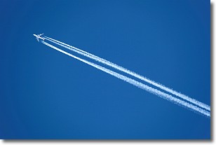
Weather Topic: What are Contrails?
Home - Education - Cloud Types - Contrails
 Next Topic: Cumulonimbus Clouds
A contrail is an artificial cloud, created by the passing of an
aircraft.
Contrails form because water vapor in the exhaust of aircraft engines is suspended
in the air under certain temperatures and humidity conditions. These contrails
are called exhaust contrails.
Another type of contrail can form due to a temporary reduction in air pressure
moving over the plane's surface, causing condensation.
These are called aerodynamic contrails.
When you can see your breath on a cold day, it is also because of condensation.
The reason contrails last longer than the condensation from your breath is
because the water in contrails freezes into ice particles.
Next Topic: Cumulonimbus Clouds
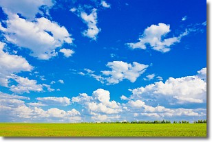
Weather Topic: What are Cumulus Clouds?
Home - Education - Cloud Types - Cumulus Clouds
 Next Topic: Drizzle
Cumulus clouds are fluffy and textured with rounded tops, and
may have flat bottoms. The border of a cumulus cloud
is clearly defined, and can have the appearance of cotton or cauliflower.
Cumulus clouds form at low altitudes (rarely above 2 km) but can grow very tall,
becoming cumulus congestus and possibly the even taller cumulonimbus clouds.
When cumulus clouds become taller, they have a greater chance of producing precipitation.
Next Topic: Drizzle
Current conditions powered by WeatherAPI.com


