Weather Alert in Ohio
Severe Thunderstorm Warning issued March 26 at 7:57PM EDT until March 26 at 9:00PM EDT by NWS Cleveland OH
AREAS AFFECTED: Cuyahoga, OH; Erie, OH; Huron, OH; Lorain, OH; Ottawa, OH; Sandusky, OH; Seneca, OH
DESCRIPTION: SVRCLE The National Weather Service in Cleveland has issued a * Severe Thunderstorm Warning for... Northern Huron County in north central Ohio... Ottawa County in northwestern Ohio... Northeastern Seneca County in northwestern Ohio... Erie County in north central Ohio... West central Cuyahoga County in northeastern Ohio... Sandusky County in northwestern Ohio... Lorain County in north central Ohio... * Until 900 PM EDT. * At 757 PM EDT, severe thunderstorms were located along a line extending from 18 miles north of Put-In-Bay to near Port Clinton to near Fremont, moving east at 60 mph. HAZARD...60 mph wind gusts and half dollar size hail. SOURCE...Radar indicated. IMPACT...People and animals outdoors will be injured. Expect hail damage to roofs, siding, windows, and vehicles. Expect damage to trees and power lines. * Locations impacted include... Lorain, Elyria, Sandusky, Norwalk, Fremont, Vermilion, Western Vermilion, Port Clinton, Kelleys Island, Put-In-Bay, Westlake, North Ridgeville, Avon Lake, Amherst, Bellevue, Clyde, Wellington, Oak Harbor, Green Springs, and Northern Milan.
INSTRUCTION: For your protection move to an interior room on the lowest floor of a building. A Tornado Watch remains in effect until 1100 PM EDT for north central, northeastern and northwestern Ohio.
Want more detail? Get the Complete 7 Day and Night Detailed Forecast!
Current U.S. National Radar--Current
The Current National Weather Radar is shown below with a UTC Time (subtract 5 hours from UTC to get Eastern Time).

National Weather Forecast--Current
The Current National Weather Forecast and National Weather Map are shown below.

National Weather Forecast for Tomorrow
Tomorrow National Weather Forecast and Tomorrow National Weather Map are show below.

North America Water Vapor (Moisture)
This map shows recent moisture content over North America. Bright and colored areas show high moisture (ie, clouds); brown indicates very little moisture present; black indicates no moisture.

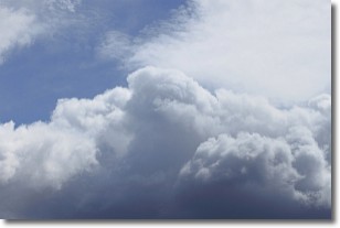
Weather Topic: What are Nimbostratus Clouds?
Home - Education - Cloud Types - Nimbostratus Clouds
 Next Topic: Precipitation
A nimbostratus cloud is similar to a stratus cloud in its formless,
smooth appearance. However, a nimbostratus cloud is darker than a stratus cloud,
because it is thicker.
Unlike a stratus cloud, a nimbostratus cloud typically brings with it the threat
of moderate to heavy precipitation. In some cases, the precipitation may evaporate
before reaching the ground, a phenomenon known as virga.
Next Topic: Precipitation
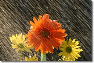
Weather Topic: What is Rain?
Home - Education - Precipitation - Rain
 Next Topic: Shelf Clouds
Precipitation in the form of water droplets is called rain.
Rain generally has a tendency to fall with less intensity over a greater period
of time, and when rainfall is more severe it is usually less sustained.
Rain is the most common form of precipitation and happens with greater frequency
depending on the season and regional influences. Cities have been shown to have
an observable effect on rainfall, due to an effect called the urban heat island.
Compared to upwind, monthly rainfall between twenty and forty miles downwind of
cities is 30% greater.
Next Topic: Shelf Clouds
Current conditions powered by WeatherAPI.com


